Aircraft Tracking with Mode S: Modez & Aviation Mapper
Aviation Mapper is LIVE! Click here to use it.
The Aviation Mapper launch video
This project is a completely home-grown implementation of an aircraft tracking system using Mode S messages received on a Universal Software Radio Peripheral (USRP) from Ettus Research. The system comprises of a software-defined baseband decoder, a GUI front-end and a real-time (smooth) JavaScript-enabled Google Earth feed.
For the Mode S/aviation/RF enthusiast: If you are interested in various notes, diagrams and screenshots that are more technical than these series of pages, please check out the dedicated page on my wiki as well.
Modez, Aviation Mapper and Software Defined Radio featured in GQ Australia (April/May)!

Screenshots from the GUI front-ends:
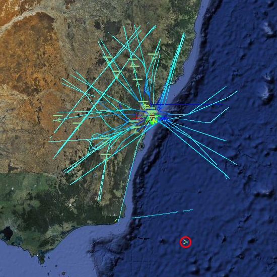
A plane at 514 km, with trails left behind showing flight corridors
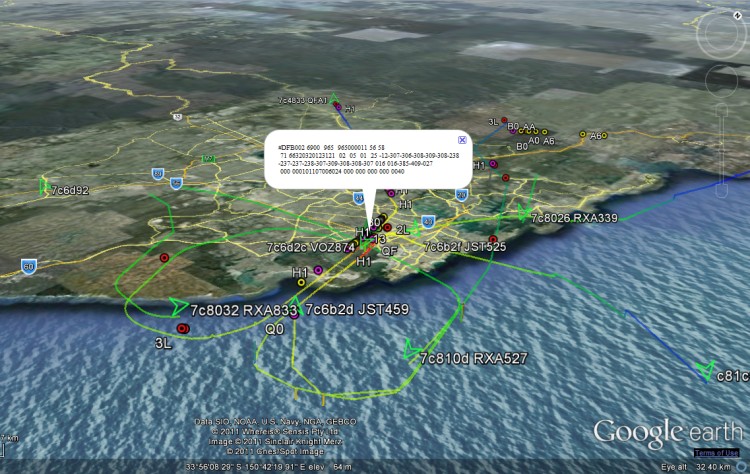
Looking at an angle at Sydney Airport, with planes landing on overlapping approach trails.
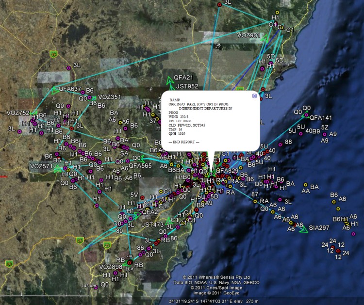
ACARS messages shown spatially as coloured dots with message label and content in balloon pop-up.
Spatial representation of ACARS message transactions building up over half a day
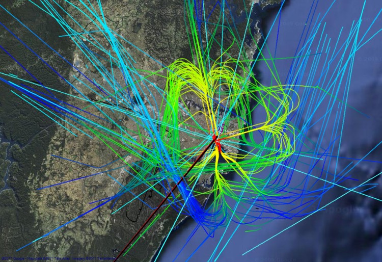
Accumulated flight paths over half a day
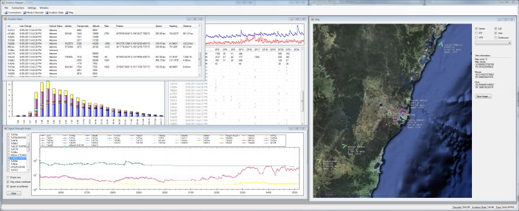
The Aviation Mapper desktop app
Running live at Sydney Airport streaming AvMap via 3G mobile Internet
Running the Aviation Mapper desktop app
Presentation at Dorkbot Sydney Finale 2011
Presentation at Ruxcon 2011: "Hacking the wireless world with Software Defined Radio
Click on a book section in the top left (or below) to explore the project further.
Popular content
Today's:
- About
- Turning the Navman S150 into a Bluetooth GPS receiver
- Update
- Simplified Makefile System
- Making your iPhone look like a NMEA GPS receiver with gpsd and WiFi or Bluetooth
- My blog lives elsewhere...
- Restore the MBR and partition information, therefore restoring the file system
- How to recover a RAID 0 disk array after losing the array’s metadata
- Aircraft Tracking with Mode S: Modez & Aviation Mapper
- Australian Geographical RadioFrequency Map
All time:
- About
- How to recover a RAID 0 disk array after losing the array’s metadata
- Making your iPhone look like a NMEA GPS receiver with gpsd and WiFi or Bluetooth
- Aircraft Tracking with Mode S: Modez & Aviation Mapper
- Australian Geographical RadioFrequency Map
- Windows Side-by-Side Assemblies (WinSxS)
- Dual monitor Quake III
- Determine the order of the physical disks in the array
- Tearable Cloth
- Software Defined Radio
Last viewed:
- Re-create the RAID 0 array with the correct settings
- Presentation at Dorkbot
- About
- Graphical Enhancements
- Appearances in TV News
- Making your iPhone look like a NMEA GPS receiver with gpsd and WiFi or Bluetooth
- Geolocation Experiment using the Mobile GSM Cellular Network
- Turning the Navman S150 into a Bluetooth GPS receiver
- Battling on the Battlefield
- Reversing My Motion Vectors
AntiSpam spam counter

Comments
Do You Still Plan To Release The Whole Program
Balint,
First of, thanks for all the work you've put towards the rtl-sdr project! I saw that you have released the web version of AviationMapper and was wondering if you still planned to release the whole program? One of your earlier comments made it sound like this may work with the rtl dongles and if this is the case this is definitely something I would mess around with. Just wondering what your plans are. Thanks!
RE: Do You Still Plan To Release The Whole Program
Hi Daniel,
Thanks for your comment. Indeed the Modez (and therefore AvMap) do work with the Realtek dongle, however the performance is a little lacklustre due to the decreased dynamic range.
AvMap plans are on short-term pause, but it's something I'll come back to soon.
Stay tuned!
Unusual landing site
First, what a brilliant concept you have there. Really nice.
Second. Was watching QF 0613, VH-VZU this morning, 2304 at around 0725 landing on RWY 34. The Flight Deck view (also really good, the MS Flight Sim guys will love it) showed it was landing at YSSY but on Google Earth it appeared to land next to Gundaroo Rd about 9nm south of the Hume Hwy.
I hope this is the sort of feedback you are looking for. Hopefully you will get this coding issue sorted and you produce an outstanding aviation app. Are you going to do one for YMML since it is a 24 hour airport, unlike YSSY with its curfew. ;-)
RE: Unusual landing site
Thanks for testing it out!
This is an interesting phenomenon: I have spent a great deal of time adding sanity checks so that corrupted position reports do not throw out airframe tracks. If an ADS-B frame is valid though, it is processed as-is. There are, in fact, a number of broken transponders, which result in very odd tracks, such as the one you saw. I have verified this with other receivers/services too - so I think chances are they're sending bad data (and AvMap is interpreting it as it ought to).
Some people have kindly offered a feed for YMML, so it will hopefully be on the map soon!
Linux suport
Hi I wand look in your map but google earth for linux don't suport in brouwser view.
And i hope that you release a kml file for showing inside google earth or a flate map like openstreetmap.
RE: Linux support
Hi, I'm really sorry that Google Earth doesn't run on Linux - I wish it did! Unfortunately I didn't go down the live-KML road, because it just doesn't allow for the kinds of things that AvMap front-end does now. 2D maps support is obviously still an option, but as there's an altitude component, I wanted to focus on 3D first...
Are you going to release AviationMapper?
Are you going to release AviationMapper?
RE: Are you going to release AviationMapper?
Yes most definitely - just needs some more tweaking and testing (also, I plan to add support for a few popular receivers, as currently it only works with my Software Defined Radio setup).
Please follow me on Twitter for updates: @spenchdotnet (http://twitter.com/spenchdotnet)
Will it support RTL2832 based
Will it support RTL2832 based dongles?
RE: Will it support RTL2832 based
Yes-ish: AvMap itself is a tracking and visualisation application, which uses network feeds as its data source. 'Modez' is the networked decoder application for any compatible GNU Radio receiver. Although AvMap does not directly connect to a physical receiver device (i.e. Software Defined Radio), you could potentially interface any device with AvMap by using the appropriate 'radio' (networked) server... more on this soon!