Hardware
Software Defined Radio
Sun, 22/05/2011 - 19:42 — balintMy Software Defined Radio experiments featured in GQ Australia (April/May) 2012!

SDR-powered Aviation Mapper is now LIVE! Click here to use it.
The Aviation Mapper launch video
Have a look at my Hi-Def intro video on using SDR on HF that was featured on Slashdot:
(The 'cheap SDR' they refer to can be found on my wiki for GNU Radio/Linux and Windows.)
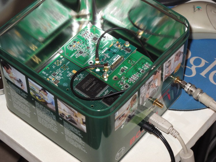
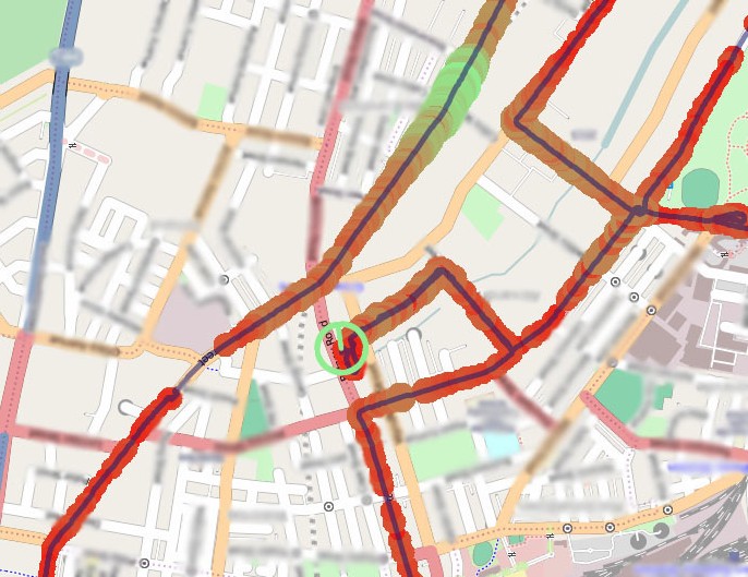
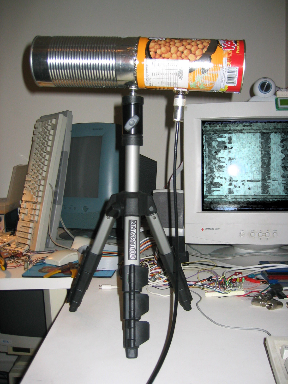
The Software Defined Radio (SDR) I currently use is the Universal Software Radio Peripheral (USRP) 1 made by Ettus Research (in a custom housing!):
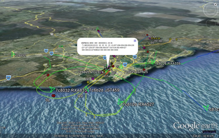
I've used it for several of my projects, including an aviation tracking system with a live streaming 3D Google Earth front-end:
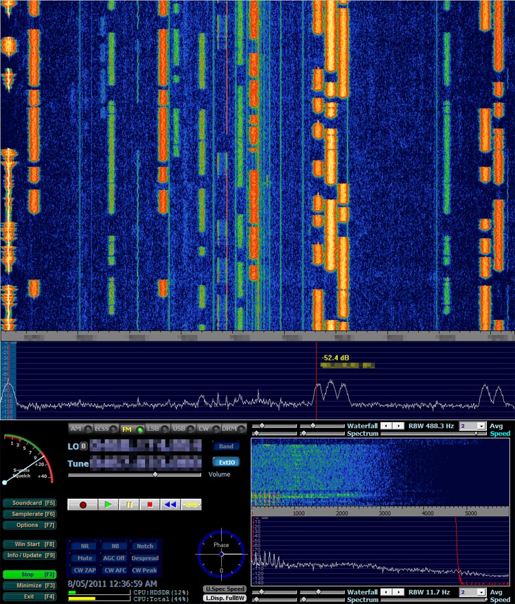
Demonstration of BorIP network streaming between HDSDR and GNU Radio using USRP 1:
Example of HDSDR using USRP:
Presentation at Dorkbot
Fri, 05/11/2010 - 23:39 — balintHere are some excerpts of the presentation Matt Robert and I gave at the October 2010 meetup of Dorkbot Sydney.
If you wish to see all of the photos from the set-up phase prior to the presentation on the roof of my apartment block, please have a look at the album in my gallery.
The Early Days
Sun, 17/10/2010 - 16:06 — balintThese are screenshots from the first working version of the system. You'll notice one obvious bug: some of the altitudes are impossibly high (the was an extra un-necessary bit shift).
If you wish to see photos of the first proper outdoor test of the system on top of the tallest hill in Sydney Park, please have a look at the album in my gallery.
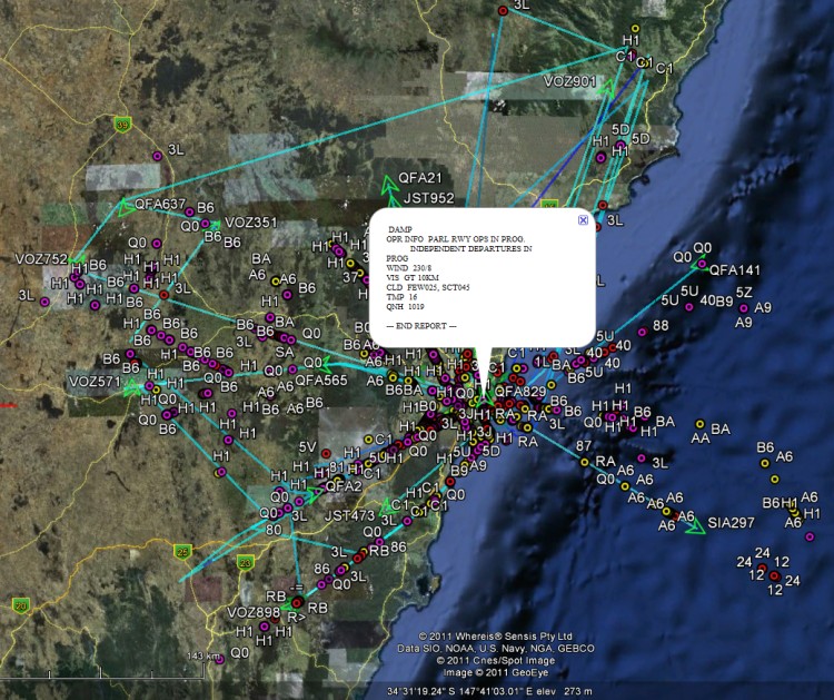
Aircraft Tracking with Mode S: Modez & Aviation Mapper
Sun, 17/10/2010 - 15:50 — balintAviation Mapper is LIVE! Click here to use it.
The Aviation Mapper launch video
This project is a completely home-grown implementation of an aircraft tracking system using Mode S messages received on a Universal Software Radio Peripheral (USRP) from Ettus Research. The system comprises of a software-defined baseband decoder, a GUI front-end and a real-time (smooth) JavaScript-enabled Google Earth feed.
For the Mode S/aviation/RF enthusiast: If you are interested in various notes, diagrams and screenshots that are more technical than these series of pages, please check out the dedicated page on my wiki as well.
Modez, Aviation Mapper and Software Defined Radio featured in GQ Australia (April/May)!
Screenshots from the GUI front-ends:
A plane at 514 km, with trails left behind showing flight corridors
Looking at an angle at Sydney Airport, with planes landing on overlapping approach trails.
ACARS messages shown spatially as coloured dots with message label and content in balloon pop-up.
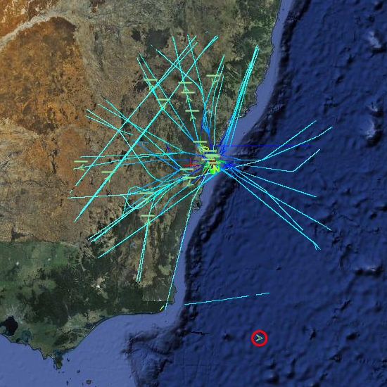
Spatial representation of ACARS message transactions building up over half a day
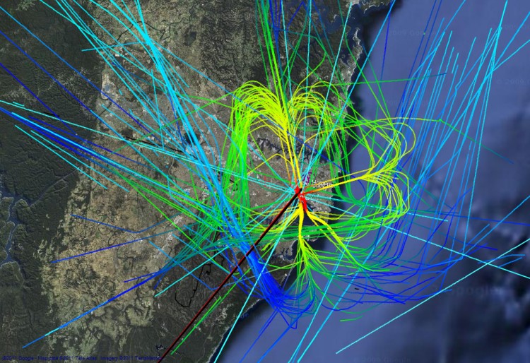
Accumulated flight paths over half a day
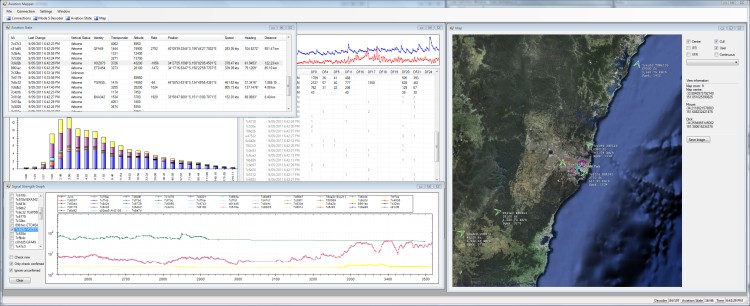
The Aviation Mapper desktop app
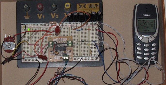
Hardware
Tue, 23/02/2010 - 13:38 — balintAn old Nokia mobile with DCT-3 firmware (for network monitor mode) is required. The phone needs to be connected to a computer via its FBUS serial interface, so some level conversion hardware is also required. Since most modern laptops do not have an external serial port, an RS-232 to USB converter is also a good idea.
Geolocation Experiment using the Mobile GSM Cellular Network
Tue, 23/02/2010 - 12:49 — balintThis experiment involved acquiring CellID and signal strength information from the GSM cellular network, tracking one's position while acquiring this data, and finally presenting it nicely. It is summarised in the following pictures (full details are described in the sub-sections found top-left):
Mapping position and signal strength measurements:
Turning the Navman S150 into a Bluetooth GPS receiver
Wed, 27/01/2010 - 14:18 — balintNavman GPS receivers, and the like, are great, until you actually want to use their received GPS data on a computer in real-time. Luckily there are plenty of resources to do this (NavmanUnlocked, the forum, MioPocket, GPSPasSion and GPSUnderground). In addition, I recommend SiRFTech for GPS testing. There are many tools available too, such as SSnap, which is extremely useful to track registry and filesystem changes. This is especially good when creating a one-off .reg file that you can import after a hard reset to restore the state of WinCE (in particular Bluetooth pairings).
Here, I give a quick guide to turning a Navman S150 into a Bluetooth GPS receiver that one can use with gpsd on a Bluetooth-enabled computer.
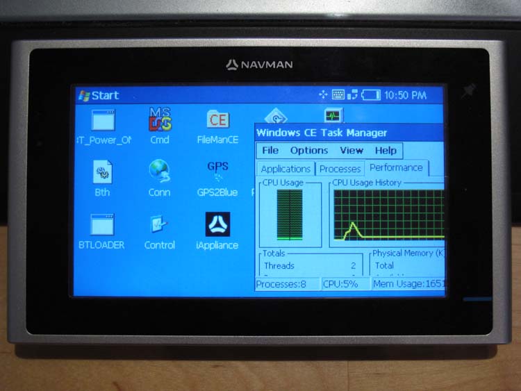
Behold the trusty S150 running WinCE Core 5 and PNADesktop (which is launched from \Program Files\Navman\appstartupsec.ini - the other apps, e.g. SmartST, are manually disabled):
Physically Controlled LED Display
Sat, 06/10/2007 - 15:59 — balintA little something I made in my spare time:
(More details coming later...)
Atmel at76c503a Wireless USB Adapter
Mon, 13/08/2007 - 11:53 — balintThis started with my desire to build a Woktenna.
Of course you can't very well put a PCMCIA wireless card at the focal point of a cooking wok!
So the alternative is using a USB WiFi adapter that can hang on the end of a USB extension cable and
introduce minimal analog signal loss and USB is digital!
Despite the fact is says "Linux compatible" on the box, it wasn't immediately possible to do what I wanted to do,
which is: monitor mode!
With monitor mode, I'd be able to point the woktenna around and pick up the beacon frames of distant APs.
I found two drivers available for this device:
one over at BerliOS,
and the other at SourceForge.
WiFi Antennas
Mon, 13/08/2007 - 11:37 — balintI have made the following WiFi antennas:
Cantenna
Made two, same design for both.
Gain is good: ~12dB.
 |
 |
 |
LED Display
Tue, 07/08/2007 - 12:18 — balintThanks to the generosity of Aras Vaichas, I came into possesion of an old (1992) 60x8 dual-colour LED display. As it was just the display itself (no manual, instructions, software, etc) I set about reverse engineering the board. Using my multimeter I re-created the schematic for the board and found all the relevant datasheets online. Having figured out how to talk to the display, I interfaced it via the parallel port and wrote some control software for it. Once I could display various test patterns (multi-colours sine waves), I 'net-enabled' the software so that the display could be controlled over a network via UDP packets - the resolution is so low that the entire LED configuration fits into a single packet! Finally, I wrote a plugin for Winamp that streams the frequency analysis of the playing song to the display, which produces results like this:
GPS-controlled Autonomous Earth Driver
Mon, 30/07/2007 - 21:39 — balint
VLF Receiver
Fri, 04/05/2007 - 14:13 — balintDr John Smith told me about these types of receivers, so I thought I'd build the bare-bones-basic one.
Unfortunately it's not possible to use it anywhere near urbanised areas due to the 50Hz mains interference 'hum' that swaps out mother nature.
Popular content
Today's:
All time:
- About
- How to recover a RAID 0 disk array after losing the array’s metadata
- Making your iPhone look like a NMEA GPS receiver with gpsd and WiFi or Bluetooth
- Aircraft Tracking with Mode S: Modez & Aviation Mapper
- Australian Geographical RadioFrequency Map
- Windows Side-by-Side Assemblies (WinSxS)
- Dual monitor Quake III
- Determine the order of the physical disks in the array
- Update
- Tearable Cloth
AntiSpam spam counter
